Stedssagn — Local legends, told as warnings
The Norwegian place-legend — a short story fixed to one exact feature of the landscape, told as report rather than tale. Why that canyon is an axe-blow, why no one farms that meadow, why a church bell is said to ring under the lake.
A stedssagn always begins with here. Not a Troll 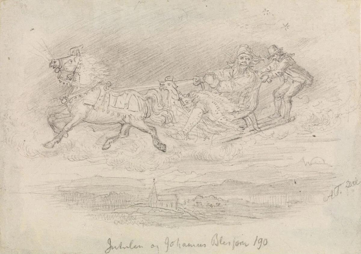 Adolph Tidemand, Jutulen og Johannes Blessom (before 1856), Nasjonalmuseet NG.K_H.B.08021 A sagn kept by name to one valley: the Vågå jutul carries Johannes Blessom home over Gudbrandsdalen through the night sky — Asbjørnsen set the legend in print in 1844. Tidemand sketches the ride itself, the giant at the reins and the farmer clinging on behind, the parish far below. The supernatural mountain-dweller of Norwegian folketro —
sometimes gigantic, like the valley-striding jutul, sometimes
small — living inside mountains and deep forest. Legends set
the troll against the church: it hurls boulders at church
buildings and flees the sound of church bells. Sunlight turns
a troll caught above ground to stone. Andreas Faye's Norske
Sagn (1833, expanded as Norske Folke-Sagn in 1844), Norway's
first legend collection, put the tradition on paper; Asbjørnsen
and Moe's Norske Folkeeventyr (1841–44) fixed the man-eating
troll of the tales in print — "De tre bukkene Bruse" was first
printed in 1843. Theodor Kittelsen (1857–1914) gave the troll
its modern visual form; his Skogtroll (1906) is in the
Nasjonalmuseet.
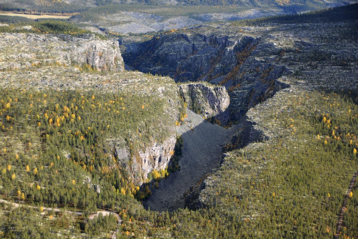
Also discussed in Troll — the monsters of the mountainsSoria Moria — the shining castle always out of reachNorske eventyr — the folk tales almost lost foreverHuldra — the girl in the forest with a secretBytting — the changeling left in the cradleVardøger — your double, arriving a few minutes before youTradisjoner — celebrations across the Norwegian year somewhere in the mountains, but the exact 2.4-kilometre gash of Jutulhogget, on the border of Alvdal and Rendalen, where — the story goes — one giant hewed the gorge to turn a river into his neighbour’s valley, until the other woke, hurled his axe across the valley and split the digger’s skull. The canyon is the giant’s cut, and Jutulhogget means just that: the giant’s hew. (Geologists now date the gorge to a meltwater flood roughly ten thousand years ago. The giants were the older explanation, and for centuries the only one anyone needed.)
Adolph Tidemand, Jutulen og Johannes Blessom (before 1856), Nasjonalmuseet NG.K_H.B.08021 A sagn kept by name to one valley: the Vågå jutul carries Johannes Blessom home over Gudbrandsdalen through the night sky — Asbjørnsen set the legend in print in 1844. Tidemand sketches the ride itself, the giant at the reins and the farmer clinging on behind, the parish far below. The supernatural mountain-dweller of Norwegian folketro —
sometimes gigantic, like the valley-striding jutul, sometimes
small — living inside mountains and deep forest. Legends set
the troll against the church: it hurls boulders at church
buildings and flees the sound of church bells. Sunlight turns
a troll caught above ground to stone. Andreas Faye's Norske
Sagn (1833, expanded as Norske Folke-Sagn in 1844), Norway's
first legend collection, put the tradition on paper; Asbjørnsen
and Moe's Norske Folkeeventyr (1841–44) fixed the man-eating
troll of the tales in print — "De tre bukkene Bruse" was first
printed in 1843. Theodor Kittelsen (1857–1914) gave the troll
its modern visual form; his Skogtroll (1906) is in the
Nasjonalmuseet.
Also discussed in Troll — the monsters of the mountainsSoria Moria — the shining castle always out of reachNorske eventyr — the folk tales almost lost foreverHuldra — the girl in the forest with a secretBytting — the changeling left in the cradleVardøger — your double, arriving a few minutes before youTradisjoner — celebrations across the Norwegian year somewhere in the mountains, but the exact 2.4-kilometre gash of Jutulhogget, on the border of Alvdal and Rendalen, where — the story goes — one giant hewed the gorge to turn a river into his neighbour’s valley, until the other woke, hurled his axe across the valley and split the digger’s skull. The canyon is the giant’s cut, and Jutulhogget means just that: the giant’s hew. (Geologists now date the gorge to a meltwater flood roughly ten thousand years ago. The giants were the older explanation, and for centuries the only one anyone needed.)
A stedssagn is a place-legend: a short story fixed to one feature of the landscape — a rock, a waterfall, a meadow, a ruin, a bend in a river. Unlike the wandering wonder-tales of princesses and trolls, which travelled district to district with no fixed address, a sagn stayed put. It was told as report, not as entertainment, and it almost always carried a warning.
The warnings were practical, dressed as legend. A boulder sitting alone in a field was a troll caught by sunrise, and you did not try to move it. A meadow where livestock kept dying belonged to the De underjordiske 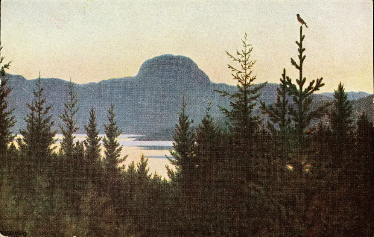 Theodor Kittelsen, Andersnatten (1903), postcard reproduction, Nasjonalbiblioteket The mountain that owns its valley — Andersnatten over Eggedal, the kind of commanding landform place-legends people with underground neighbors. Kittelsen painted it in 1903 from Lauvlia, his home across the lake. The hidden folk of Norwegian tradition — also called vetter,
tusser, or huldrefolk — who lived a parallel life under the
mounds, rocks, and ground of the farm, with cattle, weddings,
and music of their own. Unwitting offence — scalding water
thrown out without a warning shout — explained sudden sickness;
offerings of beer and food at the mound and the farm tree
(tuntre) kept the peace. Nearest of them to the household was
the gardvord, the farm's guardian — sometimes identified with
the first clearer of the ground, buried in the mound at the
farm's edge. Their most-told origin legend — Eve hiding her
unwashed children from God, who decreed that what was hidden
should stay hidden — enters the record in the collecting era
opened by Andreas Faye's Norske Sagn (1833).
Also discussed in De underjordiske — the neighbors living under your hillBytting — the changeling left in the cradle and went unfarmed. A landslip that had wiped out a farm was remembered for generations as the work of something living above the slope — and the fear was earned: Ramnefjellet at Lovatnet in the western fjords sheared its face into the lake twice, in 1905 and again in 1936, and drowned the shore villages both times.
Theodor Kittelsen, Andersnatten (1903), postcard reproduction, Nasjonalbiblioteket The mountain that owns its valley — Andersnatten over Eggedal, the kind of commanding landform place-legends people with underground neighbors. Kittelsen painted it in 1903 from Lauvlia, his home across the lake. The hidden folk of Norwegian tradition — also called vetter,
tusser, or huldrefolk — who lived a parallel life under the
mounds, rocks, and ground of the farm, with cattle, weddings,
and music of their own. Unwitting offence — scalding water
thrown out without a warning shout — explained sudden sickness;
offerings of beer and food at the mound and the farm tree
(tuntre) kept the peace. Nearest of them to the household was
the gardvord, the farm's guardian — sometimes identified with
the first clearer of the ground, buried in the mound at the
farm's edge. Their most-told origin legend — Eve hiding her
unwashed children from God, who decreed that what was hidden
should stay hidden — enters the record in the collecting era
opened by Andreas Faye's Norske Sagn (1833).
Also discussed in De underjordiske — the neighbors living under your hillBytting — the changeling left in the cradle and went unfarmed. A landslip that had wiped out a farm was remembered for generations as the work of something living above the slope — and the fear was earned: Ramnefjellet at Lovatnet in the western fjords sheared its face into the lake twice, in 1905 and again in 1936, and drowned the shore villages both times.
Some of the best are about things gone into the water. In Lake Mjøsa 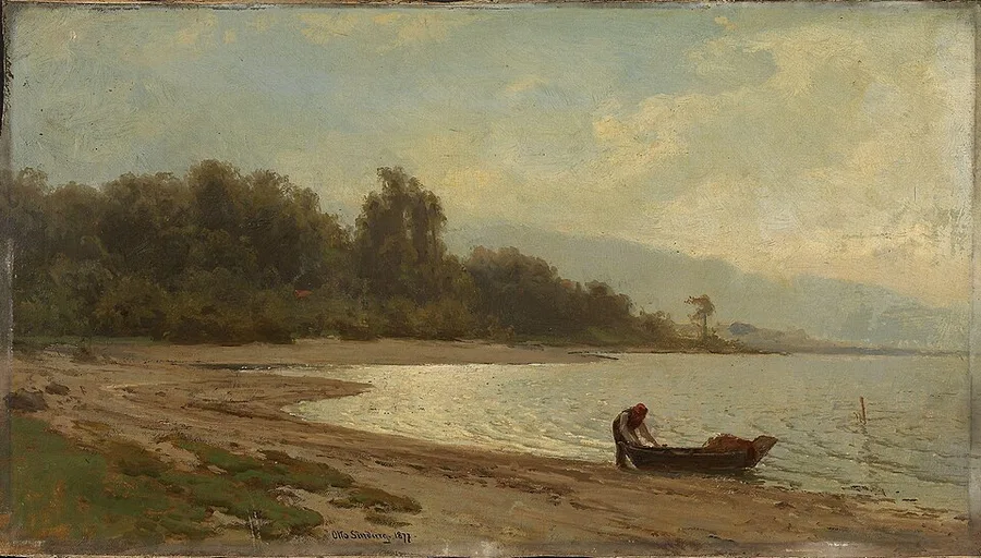 Otto Sinding, Landskap ved Mjøsa (1877), National Museum of Art, Architecture and Design Sinding's man draws his rowboat onto the Mjøsa sand at evening — calm water with a floor. Somewhere out under that still surface, the legend says, Ringebu's sunken sister bell lies where the ice and then the rope gave way, on the road that once led to Christiania. Norway's largest lake — 369 km², 117 km long, up to 449 m deep
— with Hamar, Gjøvik, and Lillehammer on its shores. Its
serpent legend is among the oldest documented sjøorm
traditions in Norway: the Hamarkrøniken, an anonymous
16th-century town chronicle, records a huge serpent off
Helgøya, shot with a crossbow by one of the bishop's men, its
stranded carcass burned. Olaus Magnus (1555) independently
records a serpent seen in Mjøsa in 1522 as a portent of King
Christian II's banishment. The lake also holds the
søsterklokkene (sister bells) legend of Ringebu Stave Church
— the votive bell that broke through the ice on its way to
Christiania and sank; a later raising nearly succeeded, but
the rope broke, and the bell is said to lie there still.
On the trip Lake Mjøsa is the water of the reunion. The Gråhårsklubben
(the Oldsters) drive south down the Gudbrandsdalen on Day 5 to
Lillehammer on the lake's shore, where the Ungdommene (the
Youngsters) have already arrived a day ahead and spend Day 5
on Storgata and at the Olympic Park. Day 5 ends with the
reunion dinner, and the reunited family spends Days 6–7 beside
the lake — Øyer Church up the valley, old-town Storgata, and
Maihaugen — before the drive south.
Lake Mjøsa Also discussed in Sjøormer — the serpents in the deep lakes and fjords , a church bell broke through the ice while it was being hauled to Christiania
Otto Sinding, Landskap ved Mjøsa (1877), National Museum of Art, Architecture and Design Sinding's man draws his rowboat onto the Mjøsa sand at evening — calm water with a floor. Somewhere out under that still surface, the legend says, Ringebu's sunken sister bell lies where the ice and then the rope gave way, on the road that once led to Christiania. Norway's largest lake — 369 km², 117 km long, up to 449 m deep
— with Hamar, Gjøvik, and Lillehammer on its shores. Its
serpent legend is among the oldest documented sjøorm
traditions in Norway: the Hamarkrøniken, an anonymous
16th-century town chronicle, records a huge serpent off
Helgøya, shot with a crossbow by one of the bishop's men, its
stranded carcass burned. Olaus Magnus (1555) independently
records a serpent seen in Mjøsa in 1522 as a portent of King
Christian II's banishment. The lake also holds the
søsterklokkene (sister bells) legend of Ringebu Stave Church
— the votive bell that broke through the ice on its way to
Christiania and sank; a later raising nearly succeeded, but
the rope broke, and the bell is said to lie there still.
On the trip Lake Mjøsa is the water of the reunion. The Gråhårsklubben
(the Oldsters) drive south down the Gudbrandsdalen on Day 5 to
Lillehammer on the lake's shore, where the Ungdommene (the
Youngsters) have already arrived a day ahead and spend Day 5
on Storgata and at the Olympic Park. Day 5 ends with the
reunion dinner, and the reunited family spends Days 6–7 beside
the lake — Øyer Church up the valley, old-town Storgata, and
Maihaugen — before the drive south.
Lake Mjøsa Also discussed in Sjøormer — the serpents in the deep lakes and fjords , a church bell broke through the ice while it was being hauled to Christiania 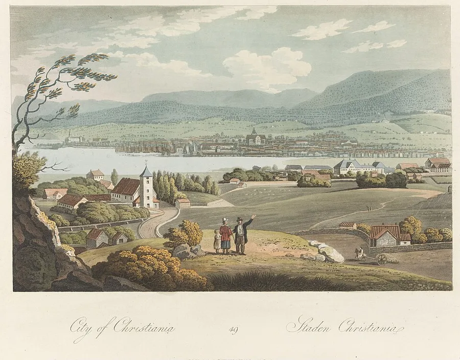 John William Edy, City of Christiania (1814), Boydell's Picturesque Scenery of Norway — National Museum of Art, Architecture and Design John William Edy's 1814 view of the small grid-planned capital across the water. This is the town King Christian IV laid out beneath Akershus after the 1624 fire razed medieval Oslo, and named for himself; its Kvadraturen grid survives today. Capital of Norway from 1624 to 1925 — the rebuilt town that
King Christian IV laid out west of the medieval Oslo after
the fire of August 1624 destroyed the old city. Christian
founded the new town on a grid plan beneath Akershus
fortress, named it for himself, and ordered the surviving
Oslo burghers to move into it. Christiania was the
capital's name through the four-hundred-year night, the
brief war of 1814, the constitutional Eidsvoll moment, the
ninety-one-year personal union with Sweden, and the first
two decades of fully independent Norway after 1905. In 1877
the spelling was modernised to Kristiania; in 1925 the
city formally returned to the medieval name Oslo. The
Kvadraturen district preserves Christian IV's grid intact
today.
On the trip Days 1–2 in Oslo bring both groups through Christiania —
Christian IV's seventeenth-century planned grid, still
visible today as the Kvadraturen district just below
Akershus fortress.
Also discussed in The 400-Year Night — when the Northern Lion lay dormantLutheran Norway and Pietism — a farmer named Hans Nielsen Hauge and a lay revival that could not be silencedThe Constitution That Saved a Nation — five radical weeks at Eidsvoll, 1814800,000 Norwegians Leave — the century that built a Second NorwayThe Quiet Revolution — how Norway won its independence without a warWorld War II — the King’s “No” and the Nazis in NorwayNorske eventyr — the folk tales almost lost foreverUtburd — the unbaptized child that will not rest and sank; the next spring it was nearly raised, but the rope broke and it went down for good — a sign, people said, that it was not to be moved — and it is said to be down there still. Lakes across the country were believed to cover drowned churches whose bells rang under the surface before a death in the parish above.
John William Edy, City of Christiania (1814), Boydell's Picturesque Scenery of Norway — National Museum of Art, Architecture and Design John William Edy's 1814 view of the small grid-planned capital across the water. This is the town King Christian IV laid out beneath Akershus after the 1624 fire razed medieval Oslo, and named for himself; its Kvadraturen grid survives today. Capital of Norway from 1624 to 1925 — the rebuilt town that
King Christian IV laid out west of the medieval Oslo after
the fire of August 1624 destroyed the old city. Christian
founded the new town on a grid plan beneath Akershus
fortress, named it for himself, and ordered the surviving
Oslo burghers to move into it. Christiania was the
capital's name through the four-hundred-year night, the
brief war of 1814, the constitutional Eidsvoll moment, the
ninety-one-year personal union with Sweden, and the first
two decades of fully independent Norway after 1905. In 1877
the spelling was modernised to Kristiania; in 1925 the
city formally returned to the medieval name Oslo. The
Kvadraturen district preserves Christian IV's grid intact
today.
On the trip Days 1–2 in Oslo bring both groups through Christiania —
Christian IV's seventeenth-century planned grid, still
visible today as the Kvadraturen district just below
Akershus fortress.
Also discussed in The 400-Year Night — when the Northern Lion lay dormantLutheran Norway and Pietism — a farmer named Hans Nielsen Hauge and a lay revival that could not be silencedThe Constitution That Saved a Nation — five radical weeks at Eidsvoll, 1814800,000 Norwegians Leave — the century that built a Second NorwayThe Quiet Revolution — how Norway won its independence without a warWorld War II — the King’s “No” and the Nazis in NorwayNorske eventyr — the folk tales almost lost foreverUtburd — the unbaptized child that will not rest and sank; the next spring it was nearly raised, but the rope broke and it went down for good — a sign, people said, that it was not to be moved — and it is said to be down there still. Lakes across the country were believed to cover drowned churches whose bells rang under the surface before a death in the parish above.
The earliest of these to reach paper were written down by parish priests and travelling officials as curiosities. The historian Gerhard Schøning entered local legends into his journal beside descriptions of antiquities, churches and farms as he crossed Gudbrandsdalen 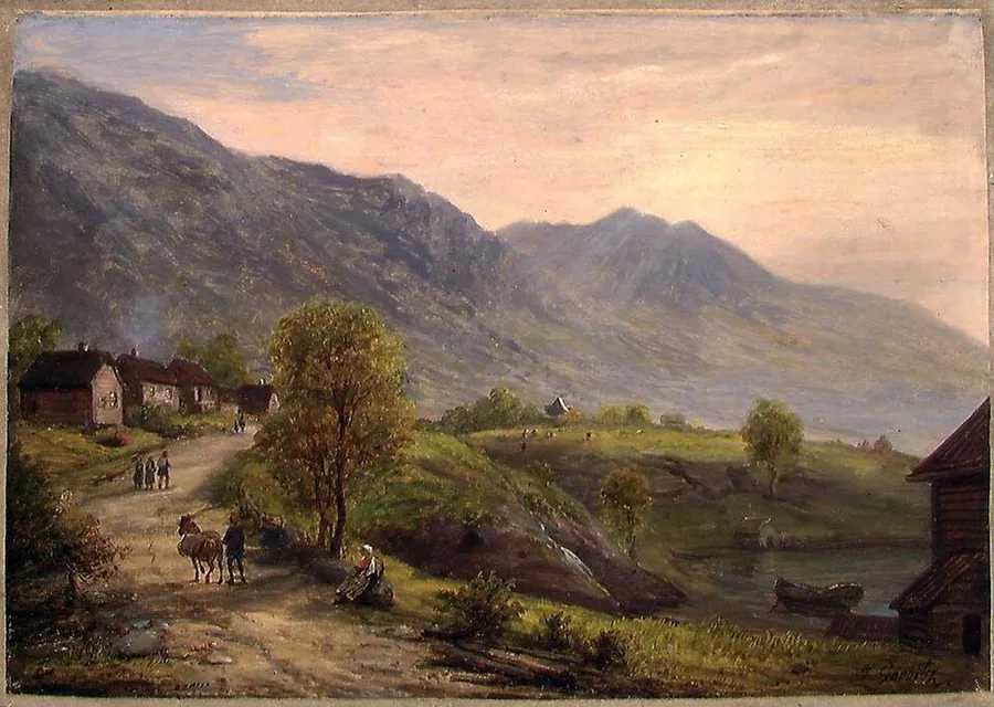 Johan Gørbitz, Fra Fåvang i Gudbrandsdalen (before 1858), National Museum of Art, Architecture and Design Gørbitz paints the valley road at Fåvang, horse and travellers winding past the log farms — the road Gerhard Schøning crossed on a royal commission in the 1770s, entering local legends into his journal beside the churches and farms he passed. Long inland valley running about 230 kilometres northwest
through the central Norwegian highland from Lake Mjøsa toward
the Dovre mountain pass, the central traffic artery between
Oslo and Trondheim across both medieval and modern eras. The
Gudbrandsdalsleden pilgrim road to Nidaros runs along the
valley; Lom Stave Church and several other surviving stave
churches stand on its slopes; Lillehammer sits at its
southern entrance. The dialect spoken in the valley is one of
the most distinctive in modern Norwegian.
On the trip The Gråhårsklubben (the Oldsters) drive the length of the
Gudbrandsdalen twice — north up the E6 on Day 3, on the long
road from Oslo to Trondheim, and south again on Day 5 to the
reunion in Lillehammer, the town at the valley's southern
entrance.
Gudbrandsdalen Also discussed in A Catholic Norway — the faith that gave the kingdom its first institutions and the stave churchesThe Long Fall — the sudden loss of Norwegian nobility, the end of the kings, and half of Norway gone foreverThe Reformation, 1537 — one church eradicated and another imposed on a royal commission in the 1770s. Most were never written at all, and lasted only as long as the people who could stand at the rock and tell you what it was.
Johan Gørbitz, Fra Fåvang i Gudbrandsdalen (before 1858), National Museum of Art, Architecture and Design Gørbitz paints the valley road at Fåvang, horse and travellers winding past the log farms — the road Gerhard Schøning crossed on a royal commission in the 1770s, entering local legends into his journal beside the churches and farms he passed. Long inland valley running about 230 kilometres northwest
through the central Norwegian highland from Lake Mjøsa toward
the Dovre mountain pass, the central traffic artery between
Oslo and Trondheim across both medieval and modern eras. The
Gudbrandsdalsleden pilgrim road to Nidaros runs along the
valley; Lom Stave Church and several other surviving stave
churches stand on its slopes; Lillehammer sits at its
southern entrance. The dialect spoken in the valley is one of
the most distinctive in modern Norwegian.
On the trip The Gråhårsklubben (the Oldsters) drive the length of the
Gudbrandsdalen twice — north up the E6 on Day 3, on the long
road from Oslo to Trondheim, and south again on Day 5 to the
reunion in Lillehammer, the town at the valley's southern
entrance.
Gudbrandsdalen Also discussed in A Catholic Norway — the faith that gave the kingdom its first institutions and the stave churchesThe Long Fall — the sudden loss of Norwegian nobility, the end of the kings, and half of Norway gone foreverThe Reformation, 1537 — one church eradicated and another imposed on a royal commission in the 1770s. Most were never written at all, and lasted only as long as the people who could stand at the rock and tell you what it was.
You can still walk to a great many of them. Trolltunga sells the troll as a brand name now, and the gorge at Jutulhogget has a signposted viewpoint — but the gorge was a sagn for centuries before it was a trailhead, and the warning came first.